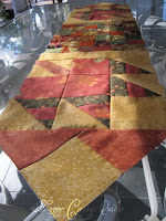
I've been fooling around with the Shop Hop leaf blocks. I never had enough fabric to make the whole quilt, so I thought I would go with a different approach. I made the two blocks and used some of the fabric from the other blocks to make up a table runner.
My first thought was to square up the block, but in the end decided that it made it too large, and I just didn't like where this was going.
The leaf blocks are large (12 1/2" square) so I cut 2 1/2" strips and made this block for the center.
And YAY it all fit!
I added a small border but it just was not working, so I ripped it out.
So the next step is the quilting. Hopefully I can get it ready to use over the Thanksgiving holiday.
Storm warnings -
Because we live in the Central Florida area, I am on the email list from a friend who works for the NOAA. Here is what Stanley sent out this morning -
- - - - - - - - - - - - - - - - - - - - - - - - - - -
I am not going to cover all of the details here since media has
covered a
lot. (Not always accurate, but much of the coverage is
good.)
Here
are some of the basics --
1) We do not have very many of these "hybrid"
systems -- a hurricane
merging with mid-latitude fronts, etc.
2) It is
VERY strong for this type of system. No we are not talking
about Cat 5
winds (max sustained for Sandy is now about 85 mph vs.
over 160 mph for
Andrew), but the wind energy is spread out over a
VERY large area. This
means that a LOT of people are going to get
strong TS-sustained winds (50-70
mph but with gusts to hurricane
force). The storm is not moving fast so
they will get those winds
for a LONG time. This means lots of trees down,
some structural
damage, disruption of normal activities, lots of power
outages, etc.,
etc.
3) This is the highest concentration of people in the
US. There are
a LOT of people that will be affected.
4) Because the wind
is spread over such a large area and the storm
has been out over the ocean
for several days, it has been generating
lots of swells/waves/etc. These
will all combine with the coastal
storm surge (which could be present during
HIGH TIDE since since the
impact will last for a number of hours). The
actual storm surge is
estimated to be at least about 11 ft in some areas,
but the other
water action, coastal topography (i.e., inlets, areas that
will focus
the flood waters, etc.) There are MANY areas that will be flooded
and
there is a chance that the New York subway system will even be
flooded.
5) It is hard to predict how much rain (and some areas might get
snow) this will produce, but unlike S FL, that area has lots of hills
that can produce dangerous flooding with moderately heavy rains. The
slower the system moves the worse the flooding will be.
6) Although I do
not put too much stock in the accuracy measurements
of historical landfalls,
this pressure for this storm is certainly
one of the lowest for a landfall
in that area. Note that the
"Perfect Storm" (1991 -- see
http://en.wikipedia.org/wiki/1991_Perfect_Storm)
was only about 972
mb and did not actually make landfall. For Hurricane
Sandy the
current pressure is 946 mb -- though fluctuations (up or down)
could
happen prior to landfall. This storm is MUCH strong than the 1991
storm.
7) The NYC/Long Island area is almost certain to receive a very
major
impact. The shape of the coast and location of the storm can funnel
a lot of surge. By the way, some of the areas are already
experiencing
TS-force sustained winds.
8) TIMING -- things are starting now, landfall is
expected by tonight
or early Tues. morning, and then depending on how slowly
storm moves,
some coastal impacts could continue through Wednesday. Inland
impacts
(check
http://www.nhc.noaa.gov/refresh/graphics_at3+shtml/092341.shtml?5-daynl?large#contents
for the track) will evolve over the next several days.
So -- wind,
rain flooding, coastal surge flooding, etc. affecting
10's of millions of
people and numerous business, cities, and states.
Please excuse any typos
or other errors. I am just trying to get
this out quickly.
PLEASE
WARN ANYONE YOU KNOW IN THE PREDICTED IMPACT AREA TO TAKE THIS STORM
SERIOUSLY.
Hope for the best; prepare for the worst!
- - - - - - - - - - - - - - - - - - - - - - - - - - - -
Praying everyone will be safe. These storms are not something to fool around with. Take care.


